ESurvey CADD 11.0

It converts point data into CAD in order to generate topographical maps
4 
Rating
Your vote:
Latest version:
14.70 See all
Developer:
ESurveying Softech (India) Pvt. Ltd.
Screenshots
1 / 1
Request
Download
link when available

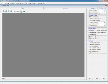
ESurvey CAD is a comprehensive solution designed for civil survey engineers for creating contours, section generation for volume calculation, earthwork quantities and converting point data into topographical map. It can import blocks and point data from CSV automatically while creating drawings, export codes, point data in different layer selectively or create total station data from CAD drawings.

Comments (1)

5 stars
15
4 stars
3
3 stars
1
2 stars
1
1 stars
4
User

Your vote:

A
amol abhale
Try this software.

Was it helpful?  yes(0) no(0) | Reply

Related software

Autodesk Map 2004
Autodesk Map 2004
Free
rating

It's software that helps you take your Map 3D skills to the next level.

Eye4Software Hydromagic
rating

Hydrographic Survey Software for Windows, Single Beam Data Collection.

Survey Import and Export
rating

The Survey Import and Export program works with AutoCAD.

Carlson Survey 2011
Carlson Survey 2011
rating

Carlson Survey 2011 comes with 64-bit capabilities, is Windows 7 compatible.

SurfStats eSurvey
SurfStats eSurvey
Free
rating

SurfStats eSurvey reduces the complexity of conducting surveys.

Related suggestions

Tags

Create contours Survey engineers Topographical map Point data Volume calculation